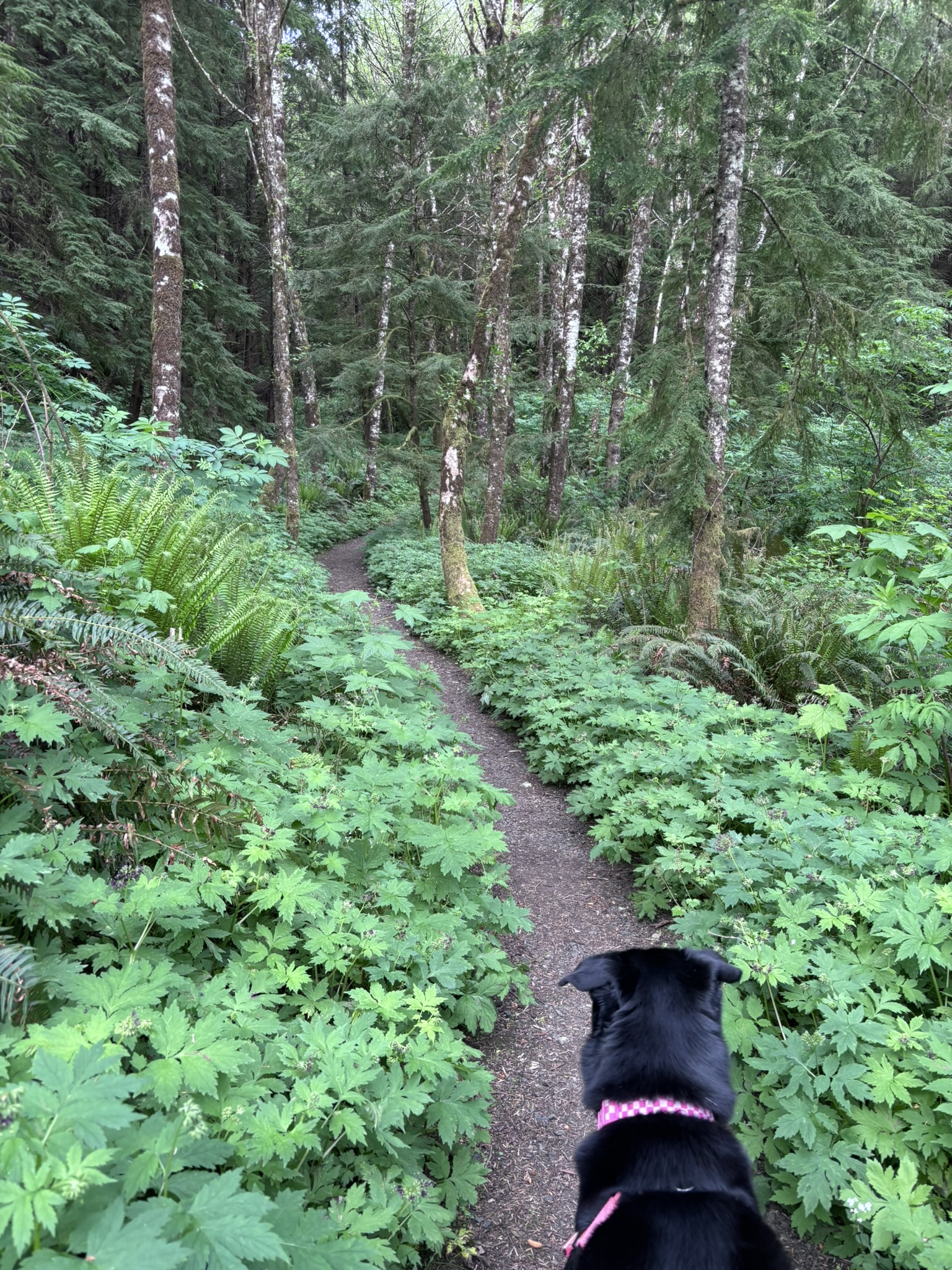
Slough to Sea Trail South Trail Stats Trail: Slough to Sea Trail South Location: Clatsop State Forest Distance: 2.3 miles (AllTrails.com) / 3.8 miles (I added some distance by starting at the Visitor’s Center) Difficulty: Moderate (Ups and down might be a bit much for creaky knees) ADA Accessible: Maybe. The trail looks like it might be designed for all mobilities, but the ups and downs are steep and at places kind of narrow. There was also a downed tree in the path when I went. Also, one of the bridges was under construction and I didn’t see any signage until I was at the bridge. Grade Padme’s Paws: 3 (out of 4) My rating: B+ (A to F) Summary The Slough to Sea trail offers a scenic and diverse hiking experience for dog owners, with beautiful wooded areas, bogs, and meadows to explore. While the trail provides plenty of natural obstacles and sensory stimulation for dogs, it also has some challenges, including a road crossing, boggy terrain, and steep hills. In this post, I share insights from hiking the trail with my dog, Padme, offering tips on water safety, trail conditions, and off-leash considerations to help you decide if this hike is right for your pup. Why It’s Good for Padme I gave this trail 3 out of 4 Padme Paws, even though it’s a pretty, wooded trail—which usually guarantees a 4-paw rating from us. The biggest drawback is that the trail “starts” at a spot where you have to cross a road to reach it. I’m not a fan of that. There are alternative routes from the visitor center, like the Kwis Kwis trail, that connect to this one—but technically, it begins right next to a road. Another issue is the boggy terrain—at least in early May. Padme loves getting into little cricks to play and drink water, but the first one she jumped into from the boardwalk had her sinking almost to her elbows. I don’t love the idea of a bog swallowing my dog for lunch. This part of the trail made me think small dogs might need to be kept on trail at all times around the bog area. I’ve had smaller dogs before and they have a lot of energy. There was nothing about the terrain of this hike that would make me warn against bringing a small dog along, except for the bog. I will say, though, that the hills tired Padme out. I didn’t think so at the time, but she slept a lot that night and was even tired the next day. Just keep that in mind if you’re deciding whether to try this hike out. Speaking of water, as you can read in Tips and Resources, always bring enough water for you and your dog. I always bring too much, and if there’s a decision to be made about who gets more water, it’s going to be Padme. She likes to jump in creeks to play and to drink. PLEASE, when you’re hiking with your dog, pay attention to the water. If it’s running, it can still be bad—you don’t know what’s upstream. I’ve always risked it, to be honest, because in my head, running water means safer. If the water is still, like in a pond, make sure it’s clear and that there are no signs posted about things like algae blooms. Maybe even call ahead to local emergency vet offices to see if any issues have been reported. Obviously, if the water is murky or green, don’t let your dog drink it or play in it. There are a couple of quick-running cricks along the trail, and there is a water station at the visitor center, so you’ll still need to bring water for your dog. Lastly, I didn’t feel entirely comfortable letting her off-leash. I did it a couple of times—we never encountered other people or dogs—but there were spots with steep ledges or thick bogs where I didn’t want her running amok (literally). On the plus side, the trail had tons of interesting smells and natural “obstacles” that Padme loved. The hills were steep, which for some reason she enjoys—even if it means dragging me behind her. Trail Notes for Dog Owners Footing: Mostly dirt and boardwalk; one downed tree required a short scramble, but the trail is otherwise clear. Terrain: Steep in places; not technical, but may tire dogs out. Water: Cricks along the trail and a water station at the visitor center; always bring extra for your dog. Off-leash: Not ideal; some steep edges and boggy areas make recall important. Best for: Energetic dogs who enjoy hills and exploring natural features. Small dogs may need supervision near bogs Why It’s Good for Me After talking about hill training last week, I wanted to challenge myself a bit. While this trail isn’t very long, the elevation profile gave me pause. Once I crossed the road to reach the main trail, the first sign I saw read “Steep Hill.” They weren’t kidding. I’m proud of myself for doing it. It was tough—I was taxed and tired. As soon as I got back in the car, my back seized up and my sciatic nerve started screaming. I gritted my teeth all the way to the local grocery store and grabbed some IcyHot. About 30 minutes later, it eased up enough for the drive to be tolerable. The variety of landscapes makes this hike worth it. You’ll pass through sparse mountain woods, lush bogs full of giant waxy plants (which surely conceal forest death monsters), and unexpectedly beautiful meadows with tall grasses and sweeping views of the slough. Also, even though the hike is associated with Fort Clatsop, it is still very much in a forest. Be mindful of big cats and bears. Rangers say these animals generally aren’t aggressive toward humans, but you should still be cautious. And especially if you have small dogs, be aware that there are big raptors (like eagles) in the
Gnat Creek Trail
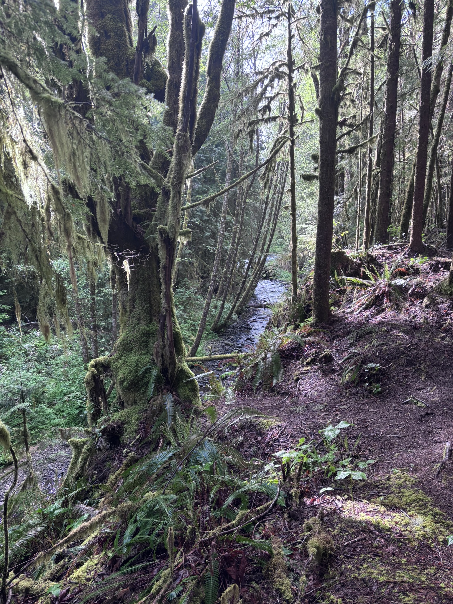
Gnat Creek Trail Trail Stats Trail: Gnat Creek Trail Location: Clatsop State Forest Distance: 7.2 miles out and back / I did 3 Difficulty: Moderate (Length, some ups and downs for creeky knees) ADA Accessible: Absolutely not (roots, uneven terrain) Grade Padme’s Paws: 4 (out of 4) My rating: B+ (A to F) Summary Gnat Creek Trail offers a lush, peaceful hike filled with mossy forests, creekside paths, and just enough elevation changes to feel rewarding. Padme, my trail-loving companion, had a blast exploring the smells, water, and natural obstacles. I appreciated the quiet, the beauty, and the mental clarity the trail brought—despite a brief road crossing and a few signs of human carelessness. This hike reminded me how far I’ve come, both physically and mentally, especially in how I face challenges like challenging terrain. Why It’s Good for Padme Anywhere with smells and water is heaven for Padme. She really loves the freedom of our hikes—shoving her head into bushes, looking over outcroppings, and overseeing the goings-on of whatever her nose is telling her. On this trail, she had plenty of obstacles to climb over and duck under. She loves splashing around in the water and running ahead on the trail just to loop back and check that I’m still coming along at my slow human pace. There were a few spots with easy water access, where she and I stepped off the trail so she could frolic in the shallows. The current was strong in some places that day, but there were calm, shallow pools too. At one point, she tried to scramble down a short, steep slope and quickly realized it wasn’t as easy as it looked. She hesitated, then wiggled her way back up toward me—something I’ve never seen her do before. She eventually pivoted and leapt up the incline. As always, I was ready to help if she needed me. Trail Notes for Dog Owners Gnat Creek Trail is dog-friendly, with signs indicating that dogs should be on leash. I’ve written before about how I decide when to let Padme off leash—whether there are people around, how good her recall is in the moment, and the general environment. On this trail, I felt comfortable letting her off leash most of the time, except in the parking lot or when we passed another hiker (which only happened once). A few things to consider if you’re hiking with your dog: The trail has some ups and downs in elevation, including areas with steep drop-offs near the water. There are access points to the creek, but not all are easy to climb down or back up—watch your dog closely. Padme listens to “be careful,” which has kept us out of trouble so far, but I never take her responsiveness for granted. Bring water and waste bags—there are no facilities for either on the trail. https://hikingwpadme.com/wp-content/uploads/2025/05/IMG_5687.mp4 Why It’s Good for Me Gnat Creek Trail is beautiful. Yes, lots of trails are beautiful, and maybe it doesn’t take much to impress me out in the woods—but I’m okay with that. The trailhead is well-marked and begins with an incline. Be not afraid, all ye who enter here—it levels off into what feels like the frolicking grounds of elven queens. The trail winds through trees in ways that feel magical—like walking into a cave or tunnel. For the first mile, you’re right beside Gnat Creek, with moss-covered trees, filtered sunlight, and a vibrant, quiet greenness that made me feel like I was in a storybook. Whoever cut this trail clearly understood how people want to feel while hiking: like they’re on an adventure… in the great American novel… or in Andor. I don’t hike just for the exercise (though I like that part). I hike for the quiet, for the sound of birds, the sight of prey trails, the rushing water. Being out here helps me stop thinking the way I usually do. It lets me be present. https://hikingwpadme.com/wp-content/uploads/2025/05/IMG_5684.mp4 What to Know Before You Go At around 1.5 miles, the trail crosses a road—that’s where Padme and I turned around. The crossing is part of why this trail doesn’t get an “A” from me. The road isn’t inside a park, and it felt wide and a bit too busy for my comfort, especially with a dog. To be clear, I didn’t turn back because of the road. I turned back because I’ve been nursing an ankle, and the gentle elevation changes had started to aggravate it. On the day I picked this trail, I’d wanted a longer one—something over four miles. My longest hike so far is eight miles, and that had real elevation challenges. I’ve done plenty of six- and seven-mile hikes, but those have mostly been flat. And while flat can be fun, there’s something about the ups and downs—even minor ones—that make me feel stronger at the end. A Bit of Personal History I used to hate hills. I’d see one and just say no. Hills meant breathing hard, which meant feeling embarrassed. I thought I’d be the only one struggling, or that I wouldn’t be able to talk normally, which also felt shameful. I didn’t want people to see how unfit I felt, and that kept me from getting any fitter. I couldn’t imagine that others were breathing hard too. Even alone, I’d think those same thoughts. But then I started taking testosterone. I have no hard data to prove a connection, just what I experienced—but around the time I started that hormone, something shifted. Suddenly, I wasn’t hearing those same critical thoughts. Or I heard them but didn’t care as much. I remember thinking “fuck it” a few times and just charging up hills without overthinking. When I noticed that change, I felt liberated. I even wondered: Is this what guys feel like? Do they not frame physical effort as embarrassment? Do they just meet challenges and move through them? I know that can’t be true for every guy, but
Navigating the Kwis Kwis to Fort-To-See Trail: A Solo Hiker’s Perspective
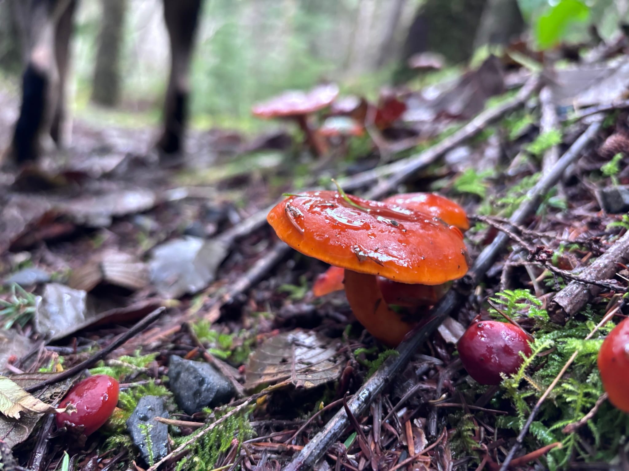
Grade: Padme’s Paws (Out of 4) My Grade (A to F) A- Hiking the Kwis Kwis to Fort to Sea Trail was a rewarding adventure for both Padme and me. Located near the Fort Clatsop Visitor Center, the trail provides not only scenic views but also a rich, immersive experience. As we walked, Padme delighted in the unique smells of the coastal landscape, making it a perfect spot for her to explore and play. With diverse flora and lush greenery surrounding the trail, the environment is as soothing as it is captivating, even for someone like me who enjoys the solitude of the outdoors. The trail offers a refreshing mix of forested sections and open areas, perfect for both dogs and humans alike. While I took my time to enjoy the sights and sounds, Padme was busy sniffing her way through the terrain, making our hike more about the journey than the destination. Whether you’re in search of tranquility, a good workout, or a pet-friendly adventure, this trail is a must-visit. Trail Stats Parking and Facilities The directions to the trailhead of this hike will take you to the visitor center for Fort Clatsop, which is a National Historic Park. There is plenty of parking and an incredible visitor’s center with educational videos, a gift/book shop and really friendly rangers. The two rangers that were there the day I did this hike even helped me figure out a weird noise I heard, which of course was hilarious as all three of us ended up making weird noises to try to approximate what I heard. They were great sports about it and why I think everyone should visit their state and national parks! To park here is $10 / day or you can buy a national parks’ pass (“America the Beautiful”), which I would absolutely recommend. The day pass is good for 7 days, however. For more information about this pass and several others, look at the section under Resources for parking information. The visitor’s center has restrooms inside, but that’s only helpful if it is open. Why It’s a Great Hike for Dogs—Or Not First, this hike is reasonably close to the ocean, so there are different smells than Padme is used to for the most part. She had a great time sniffing everything. The landscape wasn’t densely forested or littered with boulders of various sizes for Padme to play on, but she was plenty stimulated by what was there. I will say that I’m always glad that I don’t hike for time, because Padme would ruin it. My hikes are for me, but they are a little bit more for Padme so she can sniff the same spot for hours if she wants. There were a few places with elevation changes where she enjoyed pulling me and there were several sticks that she found with which to play a game of tug with me. At one point, she found a thin branch that was wider than the trail to drag around. She was so happy! I was torn because I don’t like moving things from where I find them in parks, but by the time she breaks them up into little pieces, we haven’t moved things miles, just tens of feet so I just cross my fingers about how much it disturbs the ecosystem. Why It’s a Great Hike for People This hike was gorgeous. The amount of green everywhere was soothing, but even the rot and decay felt like it only added to the beauty of the landscape. One of the trees I passed looked a bit like a body with exposed guts, which is not fun on a person, but pretty cool on a tree. Signs were also posted asking hikers not to pick mushrooms within a certain boundary, and I am thankful for it because there were so many and they were so different and so pretty. I have a friend who knows a lot about mushrooms and I wished that we were doing the hike together so she could tell me what they were called. This hike is constructed like a figure-8, having an upper and a lower loop, with a stem that goes from the loop to the visitor’s center. The whole hike is supposed to be 6.8 miles. According to the maps at the trails, too, the distances are listed as around 6.8 miles. However, by the time I reached the junction for the upper and lower loops, I realized that I already had around 4 miles. I wasn’t sure how the upper loop, which looked as big if not bigger than the lower loop, was going to only add a mile and a half to the overall hike. I decided to do only the lower loop and by the time I got to my car, I had trekked 5.23 miles. Luckily, those were fast miles because it was just so fun, but I’m still not sure of the math of the postings about the trail. Also, there were parts of this hike that were steep enough to make me need to stop to catch my breath. Well, one part. Be aware and take it slow if you are working on your fitness. Tips for Hiking Fort Cascade Trail with Your Dog Kwis Kwis to Fort to Sea Trail is a gorgeous hike that might make you breathe hard, depending on your cardiovascular fitness, but there are a couple of things to remember. Highlights and Memorable Moments One of the most memorable moments on the Kwis Kwis to Fort to Sea Trail was Padme’s pure joy as she explored the coastal smells and played with sticks along the way. Watching her drag a branch wider than the trail brought laughter and a sense of connection with nature. The trail itself was a visual treat, with vibrant green surroundings and a soothing atmosphere. There were unexpected sights, too, like a tree that looked strangely like a body with exposed guts, which added a
Latourell Falls Loop – A Pretty Hike, But Not Great for My Knees
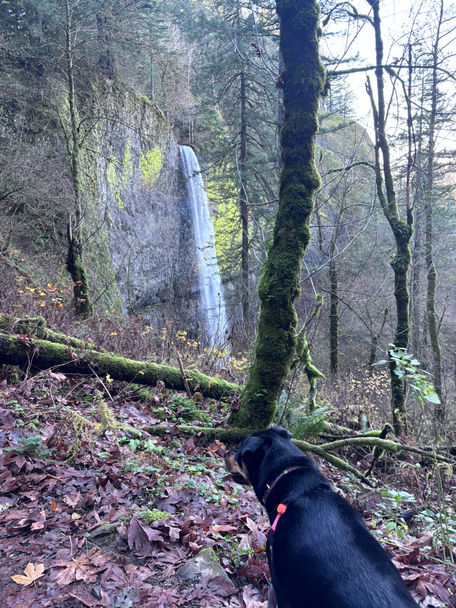
Grade: Padme’s Paws (Out of 4) My Grade (A to F) C- Hiking the Latourell Falls Loop in Guy W. Talbot State Park is an experience full of stunning sights, physical challenges, and a few unexpected surprises. This 2.85-mile trail offers breathtaking views of waterfalls and the Columbia River Gorge, but it’s not without its hurdles. Whether you’re bringing your furry hiking buddy or exploring solo, this trail has something to offer—but you’ll want to prepare for its quirks. In this review, I’ll share my honest experience hiking this trail with my dog, Padme, a 90-pound Rottweiler/Husky mix, including why it earned a “C-” grade and only 2 out of 4 paws on my dog-friendliness scale. From parking and accessibility to trail highlights and challenges, here’s everything you need to know before lacing up your boots. Trail Stats Parking and Facilities The parking situation is relatively easy, with a small main lot and a smaller overflow area nearby. The good news? There’s no parking fee. The bad news? The lots fill up fast, so arrive early, especially on weekends. The facilities here include pit toilets, but don’t expect luxury. The one I used was less than ideal—let’s just say my Shewee came in handy. While it wasn’t as bad as a poorly maintained port-a-potty, it wasn’t far off. If you’re picky about bathrooms, consider stopping elsewhere before arriving. Why It’s a Great Hike for Dogs—Or Not Let’s talk about Padme’s experience. Unfortunately, this trail didn’t quite hit the mark for her, earning only 2 out of 4 paws. Here’s why: For younger or smaller dogs, this trail might be too strenuous. If you’re bringing a pup, be prepared to carry them on the steeper sections. Why It’s a Great Hike for People: Breathing Hard and Living through the Ups and Downs Despite the challenges for Padme, I found some aspects of this hike personally rewarding. The elevation changes were a satisfying challenge, and the views made the effort worthwhile. The trail starts with a descent to the base of the larger falls, offering a dramatic and up-close view. From there, switchbacks lead up the hill. The evidence of the Civilian Conservation Corps (CCC) adds a historical touch, making the hike feel like a journey through time as well as nature. My favorite part of the hike was a small resting spot where the trail levels out. There’s a bench near a tree with a gorgeous overlook of the valley—a perfect place to catch your breath and take in the scenery. Trail Challenges: What to Watch Out For While the views and historical charm are undeniable, the trail comes with its share of difficulties: Tips for Hiking Latourell Falls with Your Dog If you’re planning to tackle this trail with a four-legged companion, here are some tips to make the experience smoother: Highlights and Memorable Moments One of the standout moments of this hike was seeing a young man dressed as a Viking, complete with a sword, posing at the base of the falls. The misty weather and dramatic backdrop made the scene look like something out of a fantasy novel. Standing at the bottom of the falls, I couldn’t help but marvel at the sheer power and beauty of nature. It’s moments like these that make hiking such a rewarding experience, even when the trail isn’t perfect.

Dog-Friendly Hike at Eagle Fern County Park Loop Trail – Conquering the Upper Loop with Padme
Grade: Padme’s Paws (Out of 4) My Grade (A to F) A Trail Stats Parking – Easy Eagle Fern County Park offers a spacious parking lot with a convenient kiosk to pay the $8 fee. If you prefer, you can use one of the following passes: There’s also a nice bathroom building with flushing toilets and heat, which can be very useful on colder days. Why It’s a Great Hike for Dogs: Exploring Padme’s Favorite Spots This trail is special to me and Padme. It’s where we first began hiking together, and it’s one of the best dog-friendly hikes in Oregon. When we first started coming here, there were several downed trees that you had to get around or over, so she learned how to jump and balance. Also, the first portion of this trail runs parallel to the river, with several places to get down to the water. That’s where I learned that she’s a water dog. The backside of the loop butts up against the hillside, with boulders and thicker vegetation that Padme loves. She learned to climb rocks here and knows exactly where she gets the most snacks for being cute. This trail has two loops—a flat half mile and a second, longer loop that goes up and then back down. When Padme was younger, and even now, we usually stay on the flat loop. This time, we did the longer loop. The elevation changes and the switchbacks were fun for her. She got to do some jumping and climbing, as well as sniff around more. I was excited to give her a new experience in a place she knows so well. Why It’s a Great Hike for People: Exploring Limits and Finding Quiet In the section about stats, I mentioned that I’d explain the difficulty level of this trail. There are two loops that make up this trail. The bottom loop is flat and about a half mile long. It is incredibly easy and beautiful. It is reasonably ADA accessible when no trees have been downed by the weather. Take the babies (fur and otherwise) to this trail! You won’t be disappointed. There’s a longer loop that goes up the hillside, about a mile long. It is steep and not ADA accessible. When I say steep, I don’t mean mountain steep, but it’s steep enough to bother my creaky knees. There is also a portion of the trail where I really wished I had my poles. That being said, I’ve done the flat portion of this trail before and love it. It’s short, so Padme and I usually do the loop a few times to get the mileage. Today, we did the whole trail, and I was pretty proud of myself. I had tried to do the entire loop when we first started coming here a few years ago. I was less fit and heavier then. I did make it up the first set of switchbacks, but it was really painful on my lungs and knees. Even though I thought it was beautiful, I was afraid that there were more climbs ahead and that I couldn’t do it. I was in pain and embarrassed about my lack of abilities, so I didn’t go any further. And I didn’t try again. But today, I did the whole thing. It was a little uncomfortable on my knees, but it was fine otherwise because I’m a lot fitter and stronger now, which is the whole goal of my journey. It made me happy and proud. I try not to regret too much because we are where we are, but as I hiked the upper loop, I wished I had tried again sooner. This loop unlocked so many beautiful sights and views. At this time of year, many of the leaves from the deciduous trees have fallen and cover the trail. This makes the trail a little tricky because it’s slippery and hides how muddy things are. But today, there were just enough yellow leaves dotting the scenery to remind me of being at my grandmother’s house in Tennessee on warm summer nights, watching the lightning bugs buzz around while I fell asleep. As comforting and beautiful as it was at times, the time of year always made itself known. The ground is getting muddier and slipperier. On steep inclines, be careful. Also, toward the end of the trail, before you rejoin the smaller loop, there’s a short, tiny section that makes me laugh. I actually ran into it the one time I tackled the upper loop before, and I hoped to avoid it this time, but no such luck. There’s a spot on the hike where, if I were under 30, I would have just easily hopped down from one level to the next. My hiking shoes have good enough traction to not slip on the rock face that slopes steeply between the two levels. The problem is that I’m of a certain age, there was mud, and I didn’t bring my hiking poles. To get past this one spot, I ended up just scootching down a little. I hate scootching, but I scootched. So, beware or be prepared. And try to enjoy the scootch. Now get out there and take your dog on a hike! Final Thoughts: Why You Should Visit Eagle Fern County Park Loop Trail with Your Dog If you’re looking for a dog-friendly hike in Oregon, Eagle Fern County Park Loop Trail is a fantastic option. Whether you stick to the flat loop or take on the challenge of the upper one, it offers something for everyone. And if you have a dog, this trail is perfect for letting them explore and have fun while you enjoy the scenery. On this hike, I not only conquered the physical challenge but also made lasting memories with Padme. It’s amazing to see how far we’ve come since our first visit, and I can’t wait to return again and again. If you’re looking for other dog-friendly hikes in the area,
As I Went Down to the River to Play
Summary: Riverside Trail #723 offered Padme and me an unforgettable adventure through the stunning Clackamas Wilderness. With autumn colors, serene river views, and thrilling wildlife sightings—including an unexpected encounter with a bald eagle—this moderate hike pushed me physically and left me in awe. Navigating tricky parking, exploring switchbacks, and discovering secluded beaches made it an ideal hike for us both. Solo hiking as a trans-masc hiker in remote areas comes with its unique reflections and preparations, but Riverside Trail #723 felt both challenging and empowering. This may just be my new favorite trail. Grade: Padme’s Paws (Out of 4) My Grade (A to F) A+ Trail Stats Parking – Confusing Parking for this trail was a little confusing. AllTrails.com said that the campground close to the trail head wasn’t an inviting place for parking unless you were camping, but that if you drove a little further there were places to park. I was I drove through the campground wondering if a road went through and past, but I didn’t see that. I pulled back on the road and immediately saw a car parked on a pull-off. But there wasn’t very much space so I didn’t try to park in that same area. I looked at the map to see if I could find a place where the trail came anywhere close to the road. It did! I drove to the end of the hike, which was not the end of the trail, and then kept going until I could find a bit of a pull off. I ended up finding a place to park where the trail was right at the road, which was really lucky. It added about 3 miles to the overall hike, but it was gorgeous and so worth it. When I reached the camp that was the turn-around point, I realized that there was a parking area that could accommodate 3 or 4 cars situated right in front of the trail head and next to the bathrooms. I think that parking area might be for the hike, but I’m not sure. I had such a good time on the extra mileage that I’ll probably just keep parking up exactly where I did. Why It’s Good for Padme This hike was so beautiful, full of switchbacks, downed trees to climb and jump, rocks to scramble up and over. Padme chased birds and chipmunks and barked at something I couldn’t see that was down a cliff below us. She had a great time! Padme and I also got to play together on a little beach while she dashed in and out of the water. She’s always been a water dog, so whenever I can get her in some, I’m going to do it. If there was one negative of this hike, it would be that even though the trail is pretty close to the river quite often, there is really only a couple of places where it was easy to access the water. Throughout her hijinks throughout the hike, she exhausted herself so much that she was tired for a whole week. To me, that’s a great hike for her. Why It’s Good for Me This trail was so much fun for me. The evidence of the fire from a couple of years ago is everywhere, but it holds its own kind of beauty, especially in contrast to the colors of the leaves changing. I saw 4 different little brown salamanders crawling across the trail, and the hike challenged me physically in a way that I hadn’t been in a while. This was my longest hike at 8 miles. I stopped so many times to take a picture or to just be in awe of how beautiful it was that it took me 3 hours to get to the halfway point. One of the most amazing moments of this hike was being surprised by an adolescent bald eagle take flight from about 20 feet away from me and just kind of soar over the river. To be honest, another just-as-amazing event was spotting the first salamander that I saw. When I got my phone out to film the little guy, he immediately started to storm toward my shoe obviously to give me a good telling off! He was very cute. A great surprise were the 3 or 4 gorgeous rough-hewn log bridges that had been built on sight. The first one I saw was almost hidden by the gorgeous trees and bushes with red and yellow leaves. Who just stumbles upon a scene like that? I do! You will too if you do the hike. The bridges were just so surprising and delightful. Closer to the area that allowed Padme and I to play on the beach, the landscape of the hike changed drastically from trees to boulders on either side of the trail. It reminded me of an area in New Jersey that I visited once. I saw a downed tree and part of the trunk had stripped itself away. The texture of the tree looked like sable. I had never seen that before and, of course, was unable to capture it in a photo. So many things on this hike just felt magical. Something that I’ve been thinking about since the last review I wrote is how these hikes might feel as a queer person or as a solo female hiker. If you’ve read my “About Us” you know that I solo hike and that I am trans masc. I am AFAB so even though I can sometimes pass, I don’t always. Thinking about the logistics of being alone in the woods never leaves my mind. I have never been on a trail where I felt uncomfortable as a queer person. I have been on a trail where people perceiving me as a female made me nervous. So that will be a topic that I bring up on these reviews from now on. The hikes I generally go to are out in very rural areas,